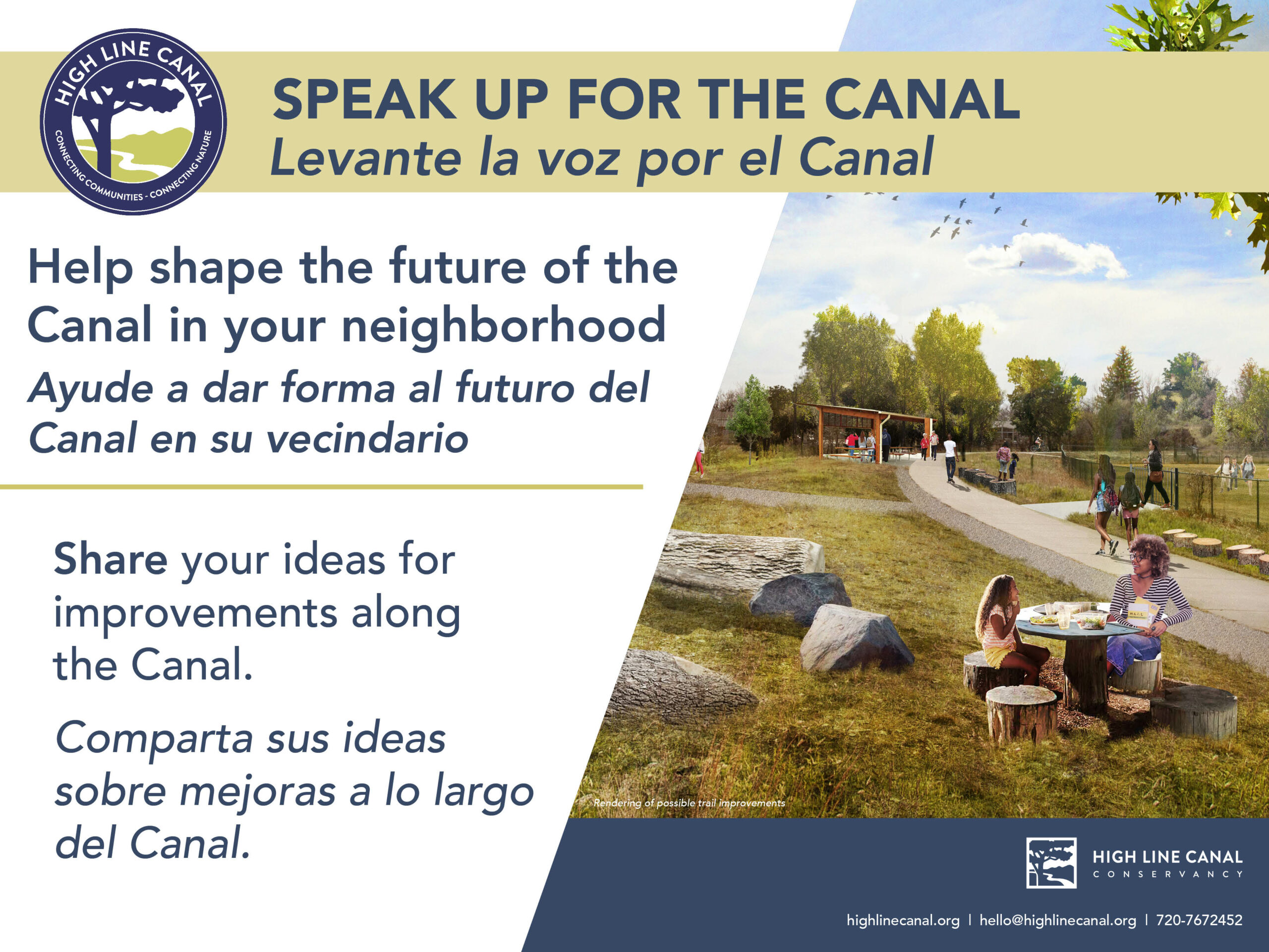
High Line Canal Trail Improvements
High Line Canal Trail Improvements
Learn about all High Line Canal projects
The High Line Canal Conservancy is working closely with Denver Water and the 11 jurisdictions along the path to improve the trail as a place for people and protect the natural habitat for vegetation and wildlife. Projects along the trail include enhancements such as new navigational signage, Canal-wide initiatives such as tree care, as well as more significant infrastructure projects such as roadway underpasses and stormwater projects. Please see below for updates and the current status of all the major projects along the 71-mile greenway.
Trail Notices + Detours
Visit our Trail Notices + Detours page to learn about projects which may impact your Canal travel.
HIGH LINE CANAL PROJECT UPDATES MAP
The map highlights current High Line Canal projects taking place along the 71-mile trail.
Trail Project List
Planning + Design Stage
Implementation Stage
Project Complete
(click project title for more information)
Miles 2-71: Signage and Wayfinding
Project Name: Miles 2-71: Signage and Wayfinding
Project Type: Signage
Project Status: Installation of wayfinding kiosks, rules signs and trailhead monuments completed. Fabrication underway on signs for street crossings.
In 2020, Aurora was the first jurisdiction to install portions of the newly designed High Line Canal sign package. In 2021, an additional 20 signs were installed as implementation of the sign package continued. In 2022, over 150 wayfinding signs will be installed across the Canal to build awareness, improve access and connect users to new parts of the trail. These new signs will include crossing signs that identify street crossings, wayfinding signs to help connect to destinations along the trail and kiosks with maps to help orient users and inform them about rules of the trail.
Project Location: Canal-wide
Project Cost: Each jurisdiction along the Canal is funding part of their sign package, with Arapahoe County Open Spaces and the High Line Canal Conservancy providing matching funds. The total project cost for this phase of signage is $506,332.
Mile 7: Solstice Stormwater Project and Linear Park
Project Name: Mile 7: Solstice Stormwater Project and Linear Park
Project Type: Stormwater Project
Project Status: Construction of the linear park is still in progress but the High Line Canal trail is open to the public
Solstice is a new residential development in Douglas County just south of Chatfield State Park. The Canal runs through the development and the developer has pulled back the banks of the Canal to convey stormwater. The developer is featuring the Canal at the center of the development, incorporating the Canal corridor into the 37-acre Solstice Park that will expand the size of the open space on either side of the Canal. The developer has planted trees to reestablish vegetation in the area, leveraging the additional stormwater that will make its way to the Canal. Construction of the stormwater infrastructure has been completed and while construction of the linear park is still in progress, the High Line Canal trail is open to the public. Visit our blog for more information.
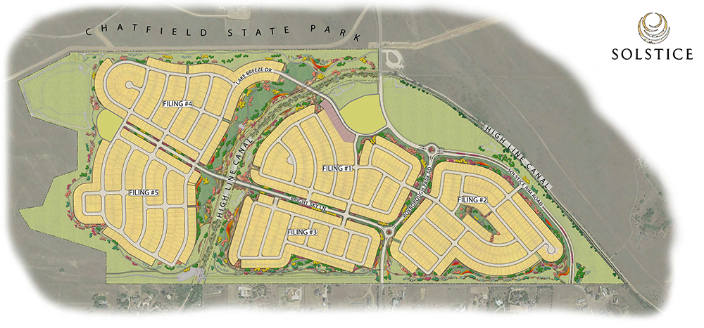
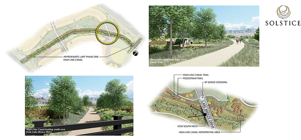
Image credit: Solstice
Trail Notice: While the trail is open to the public, construction continues in the area as the developer plants trees and builds out the linear park.
Project Location: Douglas County, Mirabelle Metro District; High Line Canal west of Roxborough Park Road
Project Cost: The project is funded by the developer and the Canal will be cared for in this reach by the newly formed Mirabelle Metro District
Miles 12-14: Santa Fe Drive/U.S. 85 Stormwater Project
Project Name: Miles 12-14: Santa Fe Drive/U.S. 85 Stormwater Project
Project Type: Stormwater Project
Douglas County recently signed a license agreement with Denver Water to formalize stormwater discharging from Santa Fe Drive into the Canal at Spring Gulch. As part of Douglas County and the Colorado Department of Transportation’s highway improvement project planned for Santa Fe Drive, an opportunity arose for the County to execute an agreement with Denver Water that formalizes the use of the Canal to convey existing stormwater from U.S. Highway 85. Stormwater runoff from the proposed highway improvement project will be pretreated before being discharged through an existing 72-inch storm sewer pipe that flows into the Canal. Douglas County will take responsibility for maintaining and managing this portion of Canal to ensure safe passage of stormwater.
Project Location: 1.5 miles of the Canal from Spring Gulch to Marcy Gulch
Project Cost: Agreement was implemented in the fall of 2021
Mile 13: Sante Fe/Highway 85 Crossing
Project Name: Mile 13: Sante Fe/Highway 85 Crossing
Project Type: Underpass
As part of the Santa Fe/Highway 85 improvements between C-470 and Highlands Ranch Parkway, a High Line Canal pedestrian underpass is being planned and funded by CDOT and Douglas County. The pedestrian crossing is estimated at $3.5 million.
Project Location: S. Santa Fe Drive and the High Line Canal
Project Cost: Estimated at $3.5 million
Mile 62: Aurora Trail Completion Phase 2: North of Colfax and I-70 Grade-Separated Crossing
Project Name: Mile 62: Aurora Trail Completion Phase 2: North of Colfax and I-70 Grade-Separated Crossing
Project Type: Crossing Enhancement
Project Status: Northern half completed, construction could begin on the southern half in early 2023
The City of Aurora is working to construct 3 miles of trail connecting the longest gap along the Canal corridor. The project is being implemented in two phases with phase 1 completed in October 2020. Phase 1 included construction of over 1 mile of trail from just north of I-70 to the border with Denver in the Green Valley Ranch neighborhood plus the installation of new signage. The second phase will include a grade-separated crossing at I-70 and trail connection to Colfax to the south, completing a section of trail that has never been formalized. Construction bids were due in late August with award anticipated by the end of the year. Construction should begin early 2023.
Learn more about the project: https://engageaurora.org/HLCT.
Project Location: High Line Canal from Colfax to Denver/the Green Valley Ranch neighborhood
Project Cost: Funding Partners: Conservation Trust Fund, Adams County Open Space Grant, Adams County Open Space Tax Shareback, Federal Transportation Improvement Program (TIP). The total project cost is currently $7,950,000.
Mile 2: High Line Canal Origin Trailhead Design
Project Name: Mile 2: High Line Canal Origin Trailhead Design
Project Type: Trailhead Enhancement
Douglas County and the Conservancy are partnering to design enhancements to The High Line Canal Origin Trailhead, located along Waterton Rd near the start of the Canal. A design process will begin in Q4, working to formalize the small parking area and access point while adding amenities and interpretation along the trail. This trailhead is intended to be an interpretive hub, educating trail users about the Canal’s unique history and connection to water in the West.
Project Location: Waterton Rd and the High Line Canal, where the Canal emerges from Waterton Canyon
Project Cost: Design funded raised by the Conservancy through the South Suburban Park Foundation and partnered with funds from Douglas County
Mile 20: Lee Gulch/Horseshoe Park Amenity Area
Project Name: Mile 20: Lee Gulch/Horseshoe Park Amenity Area
Project Type: Amenity Area
The Conservancy and South Suburban Park and Recreation District (SSPRD) are partnering on the design of amenities and safety improvements at the juncture of the High Line Canal trail and Lee Gulch trail in Littleton. These amenities will create a pause place near the historic Lee Gulch flume, one of three wooden flumes remaining on the Canal, adding seating and interpretation along with select natural play elements. These improvements build on a tree planting project in 2021 that added 50 new trees to this segment of the Canal. A final site plan has been approved by the SSPRD Board of Directors.
Project Location: Littleton
Project Cost: The Conservancy has raised funds from an anonymous foundation and will pursue a matching grant from Arapahoe County Open Spaces.
Miles 26-30: Greenwood Village Tree Planting
Project Name: Miles 26-30: Greenwood Village Tree Planting
Project Type: Tree Planting
The City of Greenwood Village has begun planting trees along the Canal, reinvigorating the tree canopy and enhancing the Canal’s ecological health. Greenwood Village planted 50 trees in 2021 (Miles 26-33) and plans to plant another 50 trees in 2022 (Miles 26-30). The planting included two varieties of Cottonwood, Boxelder, Hackberry, Bur Oak, Chinkapin Oak, Kentucky Coffeetree, Mesa Glow Maple and Catalpa. Planting is being planned for 2023 and beyond.
Project Location: Throughout the Canal in Greenwood Village
Project Cost: The City of Greenwood Village funded tree planting and continues to fund supplemental watering as the trees establish
Mile 39: Yale and Holly Underpass Design
Project Name: Mile 39: Yale and Holly Underpass Design
Project Type: Underpass
The City and County of Denver, in partnership with Arapahoe County, is advancing design and engineering of an underpass at the challenging intersection of E. Yale Ave and S. Holly St at the border of Denver and unincorporated Arapahoe County. Funding for this project was secured in Denver’s 2017 General Obligation Bond. Engineering design and construction documents will begin in 2022 and will be completed 2023. Once design is complete, utility relocation work may take several years before construction of the underpass can commence.
Project Location: High Line Canal west of the intersection of Yale Ave and Holly St
Project Cost: Funding Partners: $3.7 million secured in Denver’s 2017 General Obligation Bond
Miles 48-50: Windsor Gardens Trail Surface Enhancements
Project Name: Miles 48-50: Windsor Gardens Trail Surface Enhancements
Project Type: Trail Enhancements
Denver Parks & Recreation and the High Line Canal Conservancy are working in partnership to improve the High Line Canal trail between Parker Rd. and Havana St. The project intends to upgrade the existing 8’ asphalt trail to a 10’ concrete trail with an adjacent 6’ crusher fines trail and meet ADA standards.
Project Location: Parker Rd. to Havana St.
Project Cost: Funding Partners: The Conservancy is funding the trail surface design to 60% design for the Windsor neighborhood. The City and County of Denver is also supporting funding.
Miles 57-59: Laredo Highline Access and Awareness Improvements
Project Name: Miles 57-59: Laredo Highline Access and Awareness Improvements
Project Type: Trail Enhancements
The Conservancy is partnering with the City of Aurora and Arapahoe County Open Spaces to construct a pedestrian bridge, install signage and place natural elements along the Canal in the Laredo Highline neighborhood of Aurora between 6th Ave and Colfax Ave. The pedestrian bridge will be located where 8th Ave meets the Canal (Mile 57). Neighborhood signage and temporary natural elements were installed in the fall of 2021.
Project Location: High Line Canal from 6th Ave to Colfax Ave
Project Cost: Funding Partners: The Conservancy has raised funds for this project from The Colorado Health Foundation ($180,000) and Aurora has secured a match from Arapahoe County Open Spaces ($180,000)
Miles 37-50: Enhanced Trail Surface Design and Engineering
Project Name: Miles 37-50: Enhanced Trail Surface Design and Engineering
Project Type: Trail Enhancements
The City and County of Denver and Arapahoe County Open Spaces have begun the process of designing and engineering an enhanced trail surface for the Canal. The Plan for the High Line Canal proposes a divided trail surface in these areas, providing a concrete trail with a gravel side path that will help to separate users and improve trail safety. Design and engineering work will cover much of Denver and Unincorporated Arapahoe County, but implementation will begin in the Windsor neighborhood (miles 48-50) of East Denver.
Project Location: Design of the Canal trail from Colorado Blvd to Havana St with implementation prioritized for Parker Rd to Havana St
Project Cost: The Conservancy and Arapahoe County Open Spaces are funding the trail surface design
History of Completed Projects
See improvement projects that have been completed in previous years below. Get more details on these projects by visiting the Progress Reports on the Resources page of our website.
Hours + Rules
Hours: Open year round, 5 a.m. – 11 p.m., subject to modification by recreation agencies.
Uses: walking, nature viewing, bicycling, hiking, horseback riding, picnicking.
For more information on rules and amenities in the specific jurisdictional reaches, please visit the following:
- Denver Water Recreation
- Douglas County Parks, Trails and Building Grounds Division
- Metro District of Highlands Ranch Parks and Open Space
- South Suburban Parks and Recreation
- Greenwood Village Parks, Trails and Recreation Department
- Cherry Hills Village Parks, Trails and Recreation Department
- Denver Parks and Recreation Department
- Aurora Parks, Recreation and Open Space Department